Banda Arc YS/1G (2014-2019)
Reference: Jiang, Chengxin, et al. "A detailed earthquake catalog for Banda Arc–Australian plate collision zone using machine‐learning phase picker and an automated workflow." The Seismic Record 2.1 (2022): 1-10.
Link to catalog (txt, 1.7 Mb)
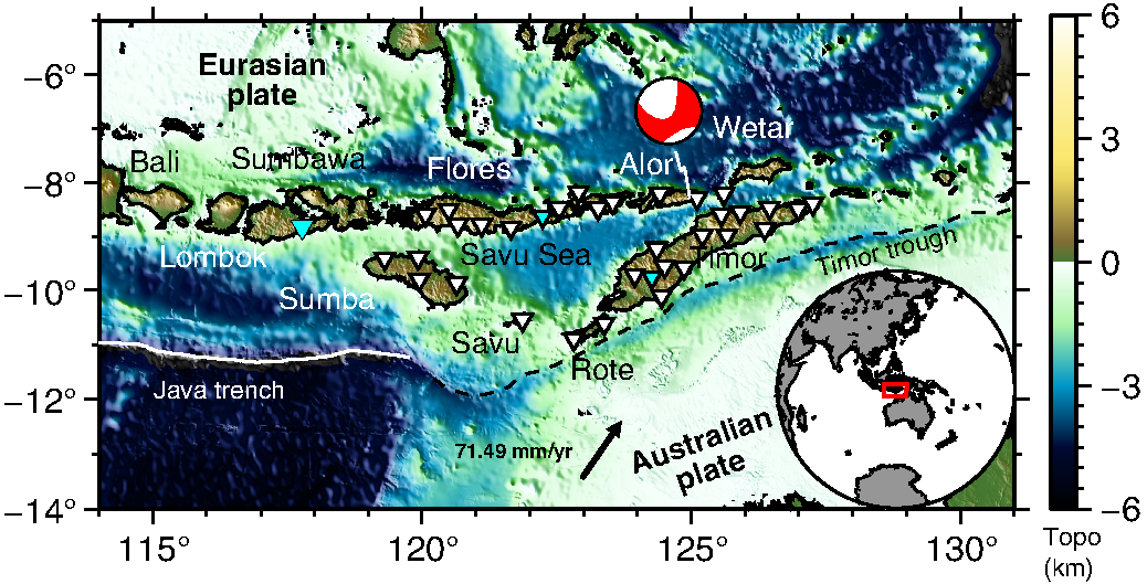
Eastern Indonesia is one of the least well understood geological domains of our planet, and yet the region provides a truly remarkable natural experiment for unraveling the complex dynamics of convergent tectonics. The recent, subduction-related collision of the Australian continental lithosphere with the active Banda arc effectively captures the initiation of convergence orogenesis and offers a rare glimpse into a process that has shaped Earth's evolution over geologic time, as well as providing fresh insights into seismic hazards confronting the world's fourth most populous country. A number of mysteries remain about the transition from subduction to arc-continental collision in the Banda arc, reflecting fundamental gaps in the general understanding of collisional tectonics.
Funding sources: AuScope
Southwest Australia 2P/WG (2000-2025)
Link to catalog data
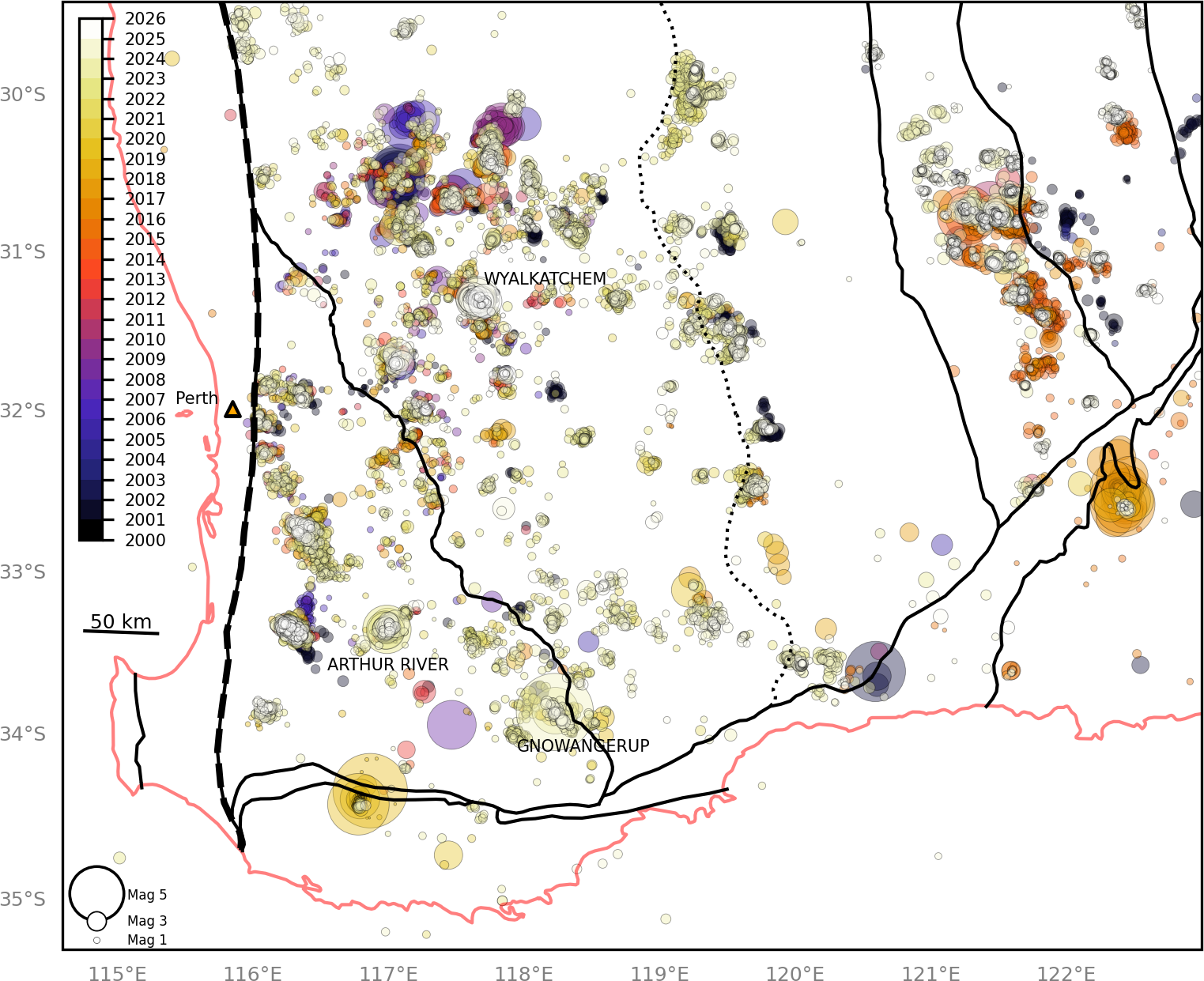
We present a new machine-learning based catalog of southwestern Australia, a stable intraplate zone primarily comprised of the Archean aged Yilgarn Craton and the continent's most seismically active region. Over 29,500 events were located between 2000 to May 2025 with 43% of these presumed to be related to anthropogenic mining based on location and temporal filtering. Most (75%) events were located following the new SWAN (2P, 2020) and WA Array networks (WG, 2022) which collectively added ~340 stations from 2020-2025 and were the first to target this region in detail. We observe a very high degree of spatially correlated clustering which contain power-law, Omori-type mainshock-aftershock behavior as well as low volume and low magnitude atemporal clustering we label as "drip-type" behavior. Drip-type clustering is presumed to reflect the long-tail baseline activity following the cessation of temporally correlated behavior following large earthquakes but may also be unrelated to past activity. As such, the identification of drip-type clusters could be used to infer the location of prehistoric seismicity and future seismic risk. Three recent significant earthquake sequences were also analyzed in detail: Arthur River (2022), Gnowangerup (2023), and Wyalkatchem (2024), which is still producing significant seismicity as of publication. In each, the distribution of hypocenters is shallow (< 5km) but mostly disorganized, no clear fault plane could be resolved, and the largest event in the sequence was preceded by a significant but smaller magnitude earthquake by several weeks to months. All three sequences also show CMT solutions consistent with the expected west-east compression regime in southwest Australia. "Drip-type" activity preceded both Gnowangerup and Wyalkatchem, but the earthquakes at Arthur River sequence were the first at that location in our catalog.
Funding sources: AuScope, DMPE
Alaska/Yakutat Z5 (2018-2022)
Reference: Meghan S. Miller, Ping Zhang, Robert Pickle, Trevor S. Waldien, and Sarah M. Roeske; Razor sharp edge – the Yakutat slab dissecting south-central Alaska (in review)
Link to catalog data
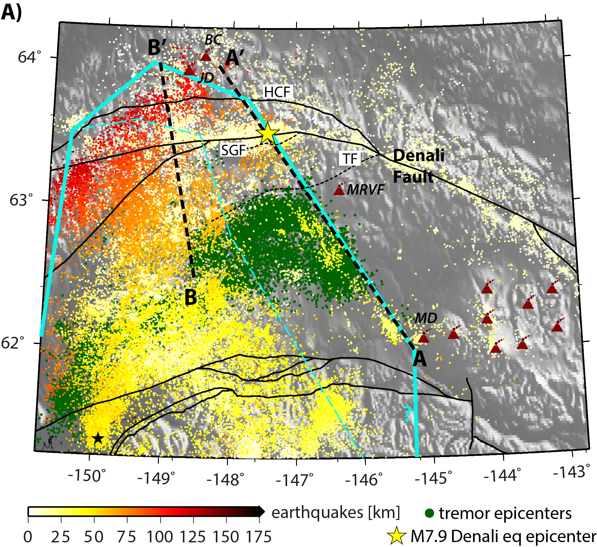
The tectonics of south-central Alaska are dominated by subduction of the Pacific plate, the Yakutat oceanic plateau, and evolution of the major continental fault system, the Denali Fault. Our new structural images show the razor-sharp edge and extent of the Yakutat slab as it subducts beneath the North American plate with remarkable detail. Thousands of small, previously undetected earthquakes form a prominent linear cluster that illuminates the precise edge of the subducted Yakutat microplate and defines the location of changing slab morphology reflecting the change in stress state. Our new seismic images and refined locations of down-dipping seismicity further elucidate the lack of mantle wedge below the Denali volcanic gap and the northeastern margin of the subducted Yakutat microplate, imaged here to be directly below the curved section of the Denali fault. We infer these features have controlled the nucleation of the 2002 M7.9 Denali Fault earthquake and the position of recent onset of volcanic fields.
Funding sources: National Science Foundation award # EAR-1828737 & Australian Research Council grant DP150102887
